Get paid To Promote at any Location
Tampilkan postingan dengan label archaeology. Tampilkan semua postingan

Selasa, 08 Maret 2011

1,000-year-old dugout canoe discovered in Florida


News from St. Petersburg Times:
The find, a 40-foot canoe, has been buried in an undisclosed location at the Weedon Island Preserve since it was first discovered in 2001 by a resident searching for old bottles.

It represents the first prehistoric seagoing vessel discovered in Florida, possibly the Southeast, and helps show the seafaring culture of a people long past...

Senin, 07 Maret 2011

Paleo-era tools from California's Channel Islands

A report in Science this month provides details about lithics recovered from the Channel Islands:
The Paleocoastal sites, dated between ~12,200 and 11,200 years ago, contain numerous stemmed projectile points and crescents associated with a variety of marine and aquatic faunal remains... provide evidence for seafaring and island colonization by Paleoindians with a diversified maritime economy.
As explained at the BBC, these finds support the idea that the original visitors to the Americas were
seafarers, rather than arriving via an "ice-free corridor" between Canadian glaciers.
"The tools that the team found hold the greatest surprise, however, in that they differ significantly from those of mainland cultures like the Clovis and Folsom. Points found on the islands - which could even be arrow-heads - are thin, serrated, and have barbed points that show striking workmanship for the period..."

"What they tell us is that there was widespread cultural diversity at the outset of human entry and dispersion throughout the Americas, and that the old, now-dead Clovis first model often misleads us to believe that there was only one major way of first human expansion throughout the Western Hemisphere."

Kamis, 03 Maret 2011

Civil war will endanger Libya's archaeology

From a report at Nature News:
Libya has an extraordinary archaeological heritage, says Paul Bennett, head of mission at the Society for Libyan Studies in London.. He explains that the country has been a "melting pot" of cultures throughout history, and has sites of Punic and Roman remains to the west, Greek and Egyptian to the east and Berber to the south. There are also important prehistoric sites, including some of the world's earliest rock and cave art, and underwater archaeological sites along the Mediterranean coast.

Libya is home to five World Heritage sites, designated by the United Nations Educational, Scientific and Cultural Organization (UNESCO): the ancient Greek archaeological sites of Cyrene; the Roman ruins of Leptis Magna; the Phoenician port of Sabratha; the rock-art sites of the Acacus Mountains in the Sahara Desert; and the old town of Ghadamès, an oasis city that has been home to Romans, Berbers and the Byzantine civilization. Security is good in these areas, says di Lernia, but may be "problematic" elsewhere...

Tripoli itself is home to two major museums, both reportedly safe at present. The national Jamahiriya Museum holds important prehistoric collections, including the oldest known African mummy, from Uan Muhuggiag in the Libyan Sahara. The museum is also housed in the ancient Red Castle of Asaraya al-Hamra, itself a heritage site. The Museum of Libya, meanwhile, contains noteworthy Greek and Roman collections...

The conflict has brought joint international–Libyan archaeological work to a standstill, and uncertainty surrounds future missions. There are thought to have been around 20 international missions in Libya, each comprising around a dozen or so archaeologists. All are now thought to be safely outside the country, having taken commercial transport home, been evacuated or taken refuge in nearby countries...

Earliest First American found in underwater cave ?

Explorers cave-diving in the Yucatan have found a human skull and the remains of a mastodon.  Excerpts from the National Geographic report:
Hoyo Negro was reached by the PET team after the divers travelled more than 4,000 feet [1,200 meters] through underwater passages using underwater propulsion vehicles, or scooters, which enabled them to cover long distances in the flooded cave system...

While the team of explorers conducted various dives for the purpose of mapping and surveying of this newly discovered pit, they noticed some peculiar bones sitting on the bottom. They first came across several megafauna remains and what was clearly a mastodon bone, while subsequent dives proved even more exciting when they spotted a human skull resting upside down with other nearby remains at about 140 feet [43 meters] depth...

Approximately 12,000 years ago, at the end of the Pleistocene epoch, Earth experienced great climatic changes. The melting of the ice caps caused a dramatic rise in global sea levels, which flooded low lying coastal landscapes and cave systems. Many of the subterranean spaces that once provided people and animals with water and shelter became inundated and lost until the advent of cave diving...

Radiometric dating of the human bones from Hoyo Negro will have to wait for now, but its location within the cave, and its position relative to the mastodon remains, are suggestive of its antiquity.
The results of this finding should definitively establish the existence of pre-Clovix humans in the New World.  I have always felt that Tom Dillehay's excavations at Monte Verde (Chile) had established a pre-Clovis timeline, but others have questioned his data.  The fact that Hoyo Negro has a skull - not just artifacts - should be definitive.

Selasa, 11 Januari 2011

Holy Land archaeology


"He who controls the present, controls the past. He who controls the past, controls the future." -- George Orwell

The aphroism above from George Orwell aptly summarizes the arguments presented in this video re ongoing controversies about archaeological work conducted in the Middle East.  To a lesser degree, the same arguments apply to the United States and other countries re artifacts related to aboriginal peoples.

Jumat, 31 Desember 2010

Sweden's ancient history

Top to bottom:
Rune stone, Herstadberg, Östergötland, Sweden. Three girls beside a rune stone (Ög 46) in Herrstaberg. The inscription says: "Vibern raised this stone in memory of Solva, his brother."

Uppsala Mounds, Gamla Uppsala (Old Uppsala), Uppland, Sweden. Excavation in 1874 of one of Uppsala Mounds - the Western Mound. A shaft was dug down to the bottom of the mound and a burnt burial site was uncovered. The three burial mounds, dated to ca. 475-550 AD, are also called the Kings' Mounds.

One of two dolmens, Snarringe, Skåne, Sweden. Man beside one of two dolmens at Snarringe hamlet. It could be from about 3500 BC.
These and many more photos of ancient monuments are assembled in a Flickr photostream of the Swedish National Heritage Board.

Selasa, 30 November 2010

Aurignacian art

"A woman views what is claimed to be the oldest known art work at the Neanderthal Museum in Mettmann, Germany. The ivory carving of a mammoth, 35,000 years old, was found in southern Germany."
Discoveries in this area were reported in Der Spiegel in 2007:
Archaeologists at the University of Tübingen have recovered the first entirely intact woolly mammoth figurine from the Swabian Jura, a plateau in the state of Baden-Württemberg, thought to have been made by the first modern humans some 35,000 years ago. It is believed to be the oldest ivory carving ever found...

In total, five mammoth-ivory figurines from the Ice Age were newly discovered at the site of the Vogelherd Cave in southwestern Germany... The geological context of the discoveries and radiocarbon dating indicate that the figurines belong to the Aurignacian culture, which refers to an area of southern France and is associated with the arrival of the first modern humans in Europe.
Additional photos at the link, and further discussion at John Hawks' Weblog.

Via Found Here.  Photo: Martin Meissner/AP

Senin, 29 November 2010

Treasures from Afghanistan

The Guardian has a photoset of objects found at Tillya Tepe, Afghanistan.  Pictured above:
"Pair of pendants depicting the Dragon Master in gold, turquoise, garnet, lapis lazuli, carnelian, and pearl. These elaborate hair ornaments depict a man wearing the tunic and flowing pants typical of nomadic dress. He holds two dragon-like creatures by their forelegs, a mythic scene known from ancient Persian and Siberian art that suggests power and invincibility" and

"Gold, turquoise, and carnelian boot buckles depicting a chariot drawn by dragons (Tillya Tepe, Tomb IV), 1st century BC-1st century AD."
About ten more items at the link.

Enjoy a walkthrough of Lascaux

The Lascaux cave website has a virtual walkthrough that is visually quite stunning.  The screencap above (click to magnify) shows a map on the lower right with a dot indicating your location; you can jump to specific sites using the navigation bar center bottom, and click on the screen for further details of selected images.

I believe the site is formed on a CGI rather than photographic basis, and you don't have any panning controls, but it's very impressive.  I had never realized how very extensive the cave is.

The website is here.  Via within the crainium.

Rabu, 27 Oktober 2010

Epigraphy on the Taikhar Chuluu in central Mongolia

The large rock pictured above (the Taikhar Chuluu) is covered with a variety of scripts which have been added by visitors over a series of millennia.  Here is an English translation from the Hungarian blog mongγol bičig & manju bithe:
Mongolia is full of interesting and beautiful places. In the central region, along the Tamir river stands the Taikhar chuluu.

This is a huge rock, there is nothing similar in the neighborhood. The stone itself is not as interesting as the inscriptions on it and the legends connected with it. Long time ago the rock was called dai gürü. Dai is a Chinese loan-word (大) meaning big, while gürü means rock in Mongolian. The modern name Taikhar is a compound of these two words (the changes d>t and g>k are absolutely normal in Mongolian, and a similar change of vowels is also acceptable). Therefore it is unnecessary to add to the name chuluu which means ‘stone’, because this would mean something like “Big rock rock” (as if one said “CD disk”). The rock has a large number of inscriptions. Unfortunately, our contemporaries also leave their scraps on it, and as a consequence several old inscriptions are disappearing. Among the graffitis there are many very old ones, some written in the Turkic age [A.D. 6th century].

The Turkic inscriptions are not just epigraphic relics, their importance goes far beyond this. In fact, they attest that the rock was revered already in the Turkic period, and this tradition was uninterruptedly transferred to the Mongols. Thus the Turkic, Mongolian and other inscriptions prove the cultural relations and continuity between the various people following each other.

There are several Mongolian inscriptions on the rock, unfortunately the majority are near to illegibility. I can not present you a large inscription, simply because I could not decypher any longer one. However, I can show two shorter one. They are not very exciting, but are worth a look.

Beginning of the inscription: oṃ sayin amuγulang boltuγai, that is: “Om, let there be peace!” I cannot completely understand the continuation of the text.

Another inscription: qamuγ amitan burqan-u qutuγ olqu boltuγai, that is: “May every living being reach the holiness of the Buddha!” These two short examples attst that the cult of the place continued after the arrival of Buddhism. This is also documented by a large number of Tibetan graffitis on the rock.

Of course, the rock itself did not come here by itself, the legend says. Long time ago there lived a hero here called Bökebilig (“Strong and wise”). Suddenly a large snake started to come out from under the earth. Bökebilig did not like this, and he pushed back the snake from where it came, and then he closed the mouth of its cave with this rock which has been standing here ever since. Not far from the rock there is a small mountain called Altan sandali (“Golden throne”), of which tradition says that Bökebilig took a rest on it, while washing his hands in the nearby Tamir river. 
Once you’re here, check the nearby graves with a number of so-called “deer stones”. They indicate that there was no cultural continuity between the original people erecting the “deer stones” and the later one digging the graves, because the “deer stones” were simply used for building material.

As their name shows, “deer stones” were mostly decorated with deers, but on a grave near Altan sandali we could also find a very special stone with horses instead of deers. Fortunately, it has survived the centuries in an excellent condition. Here you are.

There are only a handful of “horse stones” around, while you can still see hundreds of “deer stones”. It is still a question why these stones were carved and erected. Perhaps we will resolve this mystery on a day, but one thing is sure: it is worth looking around in Mongolia!
 I find this whole subject fascinating.  The rock itself doesn't look to me like a glacial erratic; perhaps some reader here can provide an opinion re its formation.  Regarding the history that it was used by a giant to crush a snake when the ground began to move in waves, I wonder if this part of the world is seismically active.

The petroglyphs are elaborate and beautiful; there are additional photos of them and of the ancient epigraphs at mongγol bičig & manju bithe.

A hat tip to "Studiolum" at  Poemas del rio Wang for locating this interesting item and providing the translation.

Jumat, 22 Oktober 2010

Sacrificial dogs and cynophagy

Patroclus had owned nine dogs who ate beside his table. Slitting the throats of two of them, Achilles tossed them on the pyre.
—Homer, Iliad, Book 23
Sacrificing dogs to appease supernatural forces has been a part of religious traditions as different as those of ancient Greece, where the Spartans slaughtered dogs to ensure victory in battle, and Shang Dynasty China. Some inscribed oracle bones dating to this period (1766-1050 B.C.) mention the rite of ning, which involved dismembering a dog to honor the winds...
At the site of Sardis in Turkey, once the capital of the Lydian Empire (680-546 B.C.), excavators uncovered 26 small pits, each containing four pots—a cooking jug, deep cup, shallow bowl, and small pitcher, all used for common meals—along with an iron knife and the bones of a puppy... the burials are the remains of a ritual meal, perhaps dedicated to the Lydian version of the god Hermes. "I do not believe these deposits are evidence of cynophagy [eating dogs], which was not part of the normal ancient Mediterranean diet," he says...
In 1937, archaeologists excavating in the Agora, the main marketplace of ancient Athens, made a stunning discovery—a well containing bones from hundreds of people, including approximately 450 newborns, and from more than 100 dogs... the dogs were "most likely sacrificed as part of a purification ritual after a birth...

But dogs weren't just sacrificed in antiquity. In Hungary, a team excavating a site in the medieval town of Kaná just outside Budapest, discovered more than 1,000 dog bones, about 12 percent of all the mammal bones at the site... Daróczi-Szabó believes that the puppies and several other dog burials at the site were intended to ward off evil, a custom that survived in Hungary into the 20th century.
Further details and discussion at the Archaeology Magazine  link.  This issue of the magazine has a series of article on dogs in archaeology.

Kamis, 14 Oktober 2010

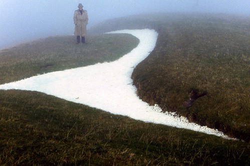
The White Horse of Uffington could be a dog

Challenging the traditional description of the Oxfordshire landmark, retired vet Olaf Swarbrick asks whether the "beautiful, stylised" figure might instead be a dog such as a greyhound or wolfhound...

Swarbrick says: "Looking at it again, it seems that it is not a horse at all: the tail and head are wrong for a horse and more suggestive of a dog. It appears more like a large hound at full stretch. I thought it may be a greyhound, but an anthropologist suggests it is a wolfhound, which (assuming it is not a horse) makes more sense."
Addendum: A closer view of the chalk-lined trench, courtesy of reader Doc Rock:

Selasa, 05 Oktober 2010

Ptolemy's locations in Germania identified

A group of classical philologists, mathematical historians and surveying experts at Berlin Technical University's Department for Geodesy and Geoinformation Science has produced an astonishing map of central Europe as it was 2,000 years ago.

The map shows that both the North and Baltic Seas were known as the "Germanic Ocean" and the Franconian Forest in northern Bavaria was "Sudeti Montes." The map indicates three "Saxons' islands" off the Frisian coast in northwestern Germany -- known today as Amrum, Föhr and Sylt...

This unusual map draws on information from the mathematician and astronomer Ptolemy, who, in 150 AD, embarked on a project to depict the entire known world. Living in Alexandria, in the shadow of its monumental lighthouse, the ancient scholar drew 26 maps in colored ink on dried animal skins -- a Google Earth of the ancient world, if you will...

Ptolemy demonstrated extensive knowledge of this remote area, indicating the locations of mountains, rivers and islands. An index lists 94 "poleis," or cities, noting their latitude and longitude accurately to within a few minutes...

Yet the data the ancient geographer used is distorted. Errors of scale crept in as he transcribed the Earth's sphere to the flat plane of a map. Ptolemy believed the northern lands to be narrower and more elongated than they are and bent Jutland in Denmark and Schleswig-Holstein in Germany too far to the east.

Ptolemy also failed to accurately connect the different parts of his map. Mistakes worked their way in despite his attempts to locate calibration points to tie together his patchwork of geographical information. The inevitable result was confusion.

Linguists and historians have tried repeatedly to decode the yellowed document -- in vain. Among researchers, it came to be known as an "enchanted castle," a mystery no one could crack. Access to Germany's prehistory was believed closed off forever...

The Berlin-based team pored over the recalcitrant data for six years, working together to develop a so-called "geodetic deformation analysis" that would help to correct the map's mistakes...

But the team of experts in Berlin had the great fortune to be able to refer to a parchment tracked down at Topkapi Palace in Istanbul, Turkey, the former residence of the Ottoman sultans. The document, consisting of unbound sheepskin pages with writing in Roman capital letters, is the oldest edition of Ptolemy's work ever discovered. A reproduction of this version is due to be published next year...

The new map suggests that minor German towns such as Salzkotten or Lalendorf have existed for at least 2,000 years. "Treva," located at the confluence of the Elbe and Alster Rivers, was the precursor to Hamburg; Leipzig was known as "Aregelia."

All this offers up rather exciting prospects, since it makes half the cities in Germany suddenly 1,000 years older than previously believed... Archaeological interest in the map will likely be correspondingly large...
The rest of the story is at Der Spiegel.

Senin, 20 September 2010

"Ice patch archaeology"


I've previously written posts both here and at Neatorama about the treasure trove of organic artifacts that are being revealed by melting, retreating glaciers.  The report above comes from Reuters (via Huffington Post).
Hunting sticks, bows and arrows, and a 3,400-year-old leather shoe are some of the discoveries thawing out in Norway's Jotunheimen mountains. In one area, the Juvfonna ice field, 600 artifacts have turned up simultaneously, making the job very difficult for Piloe and his team, as feathers, wool, and leather can turn to dust within days if not collected and stored in a freezer.
The video below discusses the situation in Oppland (central Norway).

Rabu, 15 September 2010

British treasure-hunter finds Roman helmet and mask

It's hard to type when I'm drooling with jealousy...
A Roman bronze helmet complete with face-mask - thought to be one of only three of its kind to be found in Britain - has been discovered by a metal detector enthusiast in Cumbria...

The helmet, with its enigmatic and virtually intact features, would have been worn, possibly with colourful streamers attached to the object, as a mark of excellence by Roman soldiers at cavalry sport parades.

Described as a ''hugely important discovery'', it is now expected to fetch £300,000 at Christie's Antiquities auction in London...

Selasa, 14 September 2010

Coin recovered from the WTC ship

Most people who actively prowl the intertubes have heard about the shipwreck discovered during excavations at the WTC construction site.  Now archaeologists report having found the ship's "lucky coin."
Ever since the 2nd century B.C. -- not long after Romans began minting coins -- shipbuilders have been slipping a coin into the structure of their ships. It’s a tradition that continues today. In fact, the USS New York - made partially from steel recovered from the World Trade Center towers - did it as well (Stepping the Mast is an ancient tradition where coins are placed under or near the mast when the mast is installed. The coins are intended to bring the ship good luck. The Navy and shipyard continue this tradition today and usually use coins, which add up to the ship's hull number, e.g. 17 cents for LPD 17).
You can read more about the coin (a George II half-penny) at Discovery.com.

Selasa, 07 September 2010

Finding neat stuff in the back yard

David Murray, 39, was digging behind his bungalow when he unearthed a dog tag from a German prisoner.  He got permission from his landlord to continue excavations and within an hour he had located old bottles, buttons from uniforms and used ammunition...

David has now recovered more than 2,000 items from the camp, including a live GRENADE that had to be blown up by a RAF bomb disposal unit...

”It’s really incredible to think that 70 years ago 10,000 prisoners of war were walking around in my back garden.”

The Wynches Camp opened in 1939 and first housed Italian prisoners, but later took Germans – some of whom did not leave until 1947.  The 40-acre camp, which held up to 10,000 prisoners, was situated in Much Hadham, and David’s landlord owns 20 acres of the land it stood on...
Via Nothing to do with Arbroath.

Senin, 30 Agustus 2010

Two gold coins


At the top a 2,200-year-old gold coin found in Israel, weighing about 1 ounce.  Below that a 2,300-year-old gold coin found in Bulgaria, with a depiction of the profile of Alexander the Great.

Found at FOX News.  Credits: AP Photo/Tara Todras-Whitehill (top) and AP (bottom).